
Results 11 to 20 of 56
 74Likes
Thread: Watching the tropics 2017
 LinkBack URL
 About LinkBacks
-
06-19-2017, 07:21 PM #11Junior Member

- Join Date
- Apr 2017
- Posts
- 2
- Thanks
- 2
- Thanked 0 Times in 0 Posts

Good deal thanks for the information, because you're the reel boots on the pier! :-[
bodebum likes this.
-
06-20-2017, 02:00 PM #12Senior Member

- Join Date
- Oct 2011
- Location
- Mobile, AL
- Posts
- 3,635
- Thanks
- 321
- Thanked 1,633 Times in 827 Posts
We now have TS Cindy.
Lots of heavy surf and a ton of rain, and we don't need either.eym_sirius likes this.Carl
Life is too short to drink bad beer.
Disclaimer: This post and/or report is not a substantiation of or reflection on the true accuracy of the present stock assessment methods. It is only an anecdotal report on or comment concerning local observations. Your results may vary.
-
06-20-2017, 03:36 PM #13Senior Member

- Join Date
- Jul 2012
- Location
- Orange Beach, AL
- Posts
- 5,110
- Thanks
- 4,556
- Thanked 12,070 Times in 1,928 Posts
---And muddy water. Had enough of that, too.
eym_sirius likes this.
-
06-20-2017, 03:55 PM #14Junior Member

- Join Date
- Jun 2012
- Posts
- 21
- Thanks
- 4
- Thanked 23 Times in 8 Posts
I hope you guys and girls get out of it with no flooding issues and minimal wind. I'm coming down early next week and hoping the rain effects inland doesn't create any lower salinity issues from river runoff.
-
06-24-2017, 09:21 AM #15We are there! Let's go fishing!!

- Join Date
- Oct 2011
- Location
- Born, bred and someday dead in Midtown Mobile, AL
- Posts
- 10,166
- Thanks
- 7,916
- Thanked 13,512 Times in 3,994 Posts
- Blog Entries
- 6
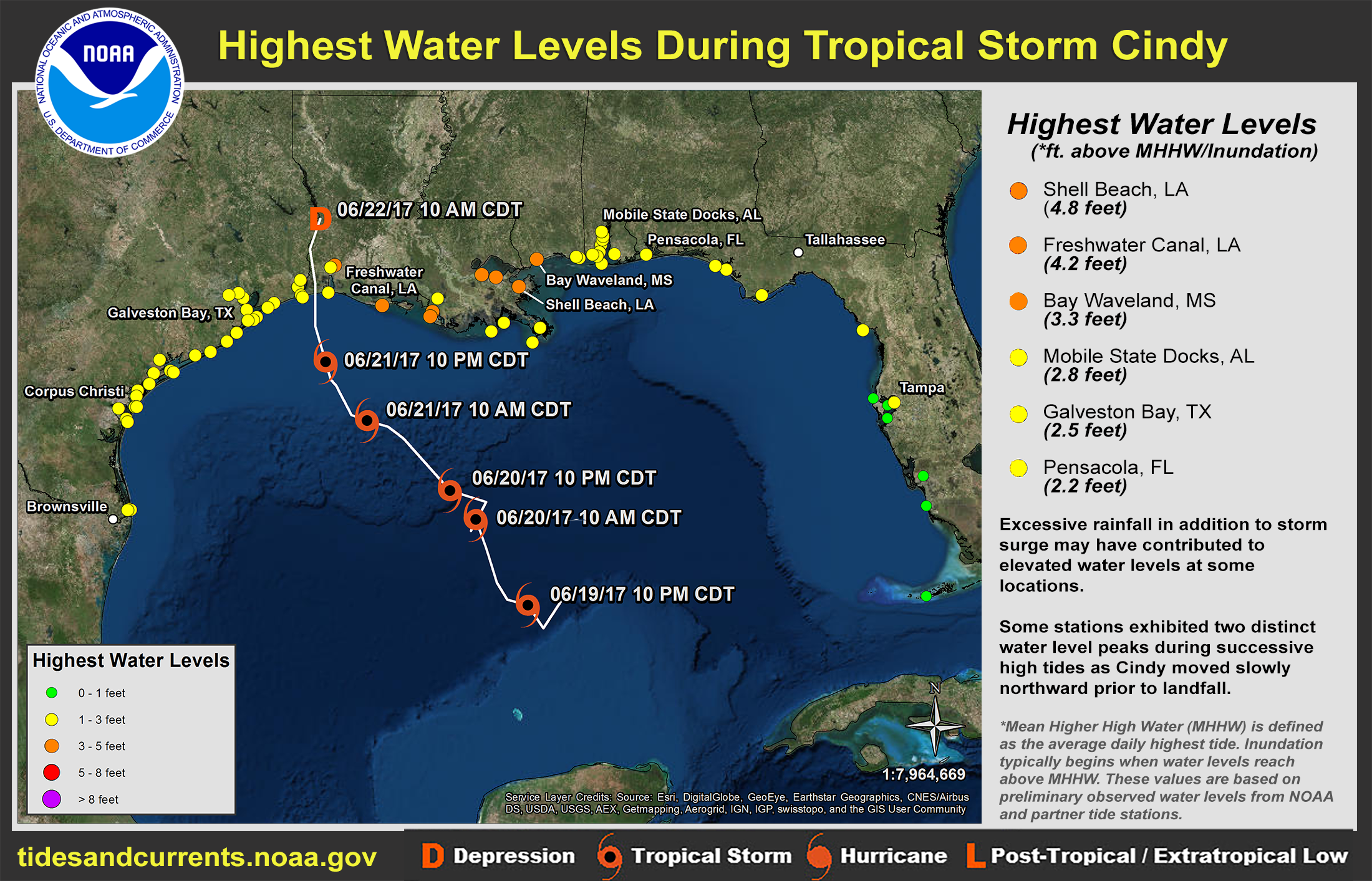
TS 'Cindy' surges...
-
06-25-2017, 09:13 AM #16We are there! Let's go fishing!!
- Join Date
- Oct 2011
- Location
- Born, bred and someday dead in Midtown Mobile, AL
- Posts
- 10,166
- Thanks
- 7,916
- Thanked 13,512 Times in 3,994 Posts
- Blog Entries
- 6
Something we may relate better to a little closer to 'home',
the water levels from Perdido Pass as the storm formed and dissipated...
(RETIRED) mostly.
Now part-time outdoor writer,
former Pier & Shore Fishing Guide
http://www.pierpounder.com
-
08-07-2017, 10:12 PM #17We are there! Let's go fishing!!
- Join Date
- Oct 2011
- Location
- Born, bred and someday dead in Midtown Mobile, AL
- Posts
- 10,166
- Thanks
- 7,916
- Thanked 13,512 Times in 3,994 Posts
- Blog Entries
- 6
Looks like we can expect a 'small' groundswell (may reach 4 feet) from the transit of TS "Franklin" beginning in about 24 hours, peaking Wednesday near noon (high tide) and lasting into Thursday afternoon/evening...
NWPS - Nearshore Wave Prediction Systemperdidohunter and Gulfyakr like this.
-
The Following 5 Users Say Thank You to Pier#r For This Useful Post:
-
08-08-2017, 12:23 PM #18Junior Member
- Join Date
- Jun 2017
- Posts
- 10
- Thanks
- 14
- Thanked 3 Times in 3 Posts
That is a dandy tool for planning purposes, Pier#r. Thank you for posting the link.
Pier#r likes this.
-
08-08-2017, 04:43 PM #19Senior Member
- Join Date
- Jul 2012
- Location
- Lay Lake - Coosa River
- Posts
- 912
- Thanks
- 744
- Thanked 869 Times in 294 Posts
looks like Franklin going ashore today on Yucatan peninsula. Expected to drop to tropical storm then restrengthen over water and reach near hurricane status and go back ashore south of Tampico Mexico..
-
08-22-2017, 03:41 PM #20We are there! Let's go fishing!!
- Join Date
- Oct 2011
- Location
- Born, bred and someday dead in Midtown Mobile, AL
- Posts
- 10,166
- Thanks
- 7,916
- Thanked 13,512 Times in 3,994 Posts
- Blog Entries
- 6
'Harvey'
indirectly sent a short-lived 2'-3' groundswell into our area this am.
Indications are it will likely regenerate in the SW GoM and move NW to the Texas coast.
The winds and seas could increase here later in the week (along with more rain)...
 chillinfish likes this.
-
The Following 3 Users Say Thank You to Pier#r For This Useful Post:


 Reply With Quote


Well, after several hours making phone calls, I was able to track down a certain manufacturers service center in California. Thankfully, they agreed to send out my needed parts. These were left over...
You would think I would know this!