
Results 1 to 10 of 14
 22Likes
Thread: Water depth along the pier
 LinkBack URL
 About LinkBacks
-
03-02-2014, 04:09 PM #1Senior Member

- Join Date
- Oct 2011
- Posts
- 1,564
- Thanks
- 291
- Thanked 1,568 Times in 400 Posts
Water depth along the pier
Like most regulars,I've been asked dozens of times while fishing"how deep is the water?",well we give a guess and continue fishing. The kids and I got into a conversation last night about how the depth has changed over the last few years and how big the sandbar has gotten. With the chart showing slight tide change,I figured today would be a good day to check the depth at several places along the pier. Our equipment was a handline reel loaded with twine,a 16oz lead attached to the end and zipties for visible markers every 5'(30' up the line). The current was ripping hard from east to west so there was some belly in the line,but the water was over a foot below the live barnacle line so I feel this is darn close. The only depths I feel are false are the ones on the sandbar because the water is a little deeper strait down than 30' out. Whiting hole 100' from pier house:6',Deep spot 50' before first handicap station on west side:12',first handicap station east side:7',east side first octi:12',west side first octi:10',spanish mackerel area on east side 30' past bathrooms 15'(BTW several nice size spanish were in there today flashing and jumping but not many cuaght,we saw a dozen or so following Garret's jig up while talking to him), approx. 100' past the bathrooms east side:17',handicap station between bathrooms and end:21',west side of octi:26',east side of octi:25',the very end of pier:28' and the deepest spot was 20' before you enter the octi and it was 29'. Well that's about it,I have no idea if anybody else was curious about the depths like me,just wanted to share. About all I can say,it's nice to know we've only lost a couple feet on the end since the piers' been built.
-
-
03-02-2014, 04:31 PM #2Dufus Tourist

- Join Date
- Jan 2013
- Location
- Athens, Alabama
- Posts
- 2,106
- Thanks
- 410
- Thanked 1,575 Times in 518 Posts
It would be nice to make this a sticky on the FAQ page.
ShallowWaterAngler and bodebum like this.
-
03-03-2014, 06:31 AM #3Senior Member
- Join Date
- Jul 2012
- Location
- Robertsdale, Al
- Posts
- 111
- Thanks
- 1
- Thanked 157 Times in 24 Posts
I already drew a hand scrawled map, with the depths John G noted, and have been comparing his notes to my favorite spots on the pier. Terrific information since I was always curious and no one had anything definitive when discussing it. Excellent reference.
FinChaser likes this.
-
03-03-2014, 09:20 AM #4We are there! Let's go fishing!!

- Join Date
- Oct 2011
- Location
- Born, bred and someday dead in Midtown Mobile, AL
- Posts
- 10,181
- Thanks
- 7,959
- Thanked 13,531 Times in 4,000 Posts
- Blog Entries
- 6
That's
 John!
John!
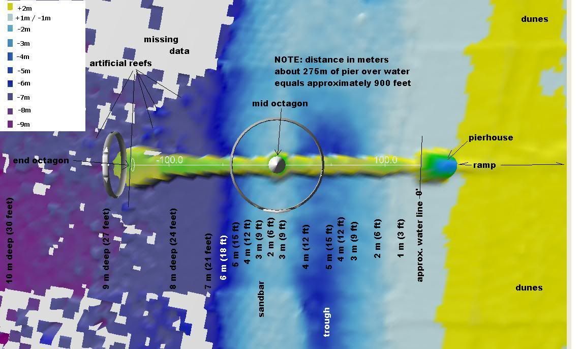
To compare, here is the 2008 bathymetry (approximate: based on water 'color')...
GSPPier-2008-Bath.jpg
And some digital bathy taken in 2010 by the company I worked for...
 ShallowWaterAngler likes this.(RETIRED) mostly.
Now part-time outdoor writer,
former Pier & Shore Fishing Guide
http://www.pierpounder.com
-
The Following 4 Users Say Thank You to Pier#r For This Useful Post:
-
03-03-2014, 09:36 AM #5Senior Member

- Join Date
- Oct 2011
- Location
- Arkansas
- Posts
- 1,136
- Thanks
- 572
- Thanked 1,115 Times in 285 Posts
".....and the deepest spot was 20' before you enter the octi and it was 29'"
Was that deep spot on the East or West side?
-
03-03-2014, 10:11 AM #6Senior Member

- Join Date
- Oct 2011
- Location
- Mobile, AL
- Posts
- 3,635
- Thanks
- 321
- Thanked 1,633 Times in 827 Posts
#R:
Is that LIDAR?
BTW, you better get on the ball: 1st fish fry at the church is this Friday!Carl
Life is too short to drink bad beer.
Disclaimer: This post and/or report is not a substantiation of or reflection on the true accuracy of the present stock assessment methods. It is only an anecdotal report on or comment concerning local observations. Your results may vary.
-
03-03-2014, 12:18 PM #7Senior Member

- Join Date
- Jul 2012
- Location
- Orange Beach, AL
- Posts
- 5,112
- Thanks
- 4,589
- Thanked 12,071 Times in 1,929 Posts
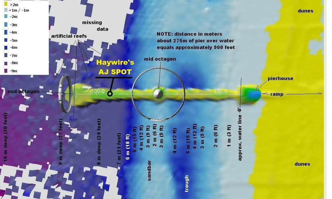
Thank goodness you didn't find and publish my secret hole where I catch all those big amberjack.
-
03-03-2014, 12:34 PM #8Old Fart

- Join Date
- Oct 2011
- Location
- Gulf Shores, AL
- Posts
- 4,816
- Thanks
- 1,260
- Thanked 2,164 Times in 767 Posts
[QUOTE=Haywire;71392]Thank goodness you didn't find and publish my secret hole where I catch all those big amberjack.[/QUOT
Sorry Bro, but you need to share such helpful info!
-
The Following 3 Users Say Thank You to FinChaser For This Useful Post:
-
03-03-2014, 01:04 PM #9We are there! Let's go fishing!!
- Join Date
- Oct 2011
- Location
- Born, bred and someday dead in Midtown Mobile, AL
- Posts
- 10,181
- Thanks
- 7,959
- Thanked 13,531 Times in 4,000 Posts
- Blog Entries
- 6
Yes. Originally Posted by CarlF

It was a 'little something' I requested (to my bosses) as a test for the capabilities of the bathymetric sensor to show the USCOE for the coastal project...
2010 US Army Corps of Engineers (USACE) Joint Airborne Lidar Bathymetry Technical Center of Expertise (JALBTCX) Topobathy Lidar: Alabama Coast and Florida Gulf Coast - CKAN
The exact location of Haywire's so-called SECRET fishing hole will remain CLASSIFIED
as long as his "contributions" continue ;-)chillinfish and Haywire like this.(RETIRED) mostly.
Now part-time outdoor writer,
former Pier & Shore Fishing Guide
http://www.pierpounder.com
-
03-03-2014, 01:53 PM #10Old Fart
- Join Date
- Oct 2011
- Location
- Gulf Shores, AL
- Posts
- 4,816
- Thanks
- 1,260
- Thanked 2,164 Times in 767 Posts


 Reply With Quote


Yesterday I caught a Smooth Puffer fish in the surf. Looked sort of like a northern puffer or Blowfish which are great to eat. But then I researched it and "7. Are smooth back puffer fish...
Which are DO NOT EAT fish?